File:ET Afar asv2018-01 img48 Dallol.jpg

Original file (7,952 × 4,473 pixels, file size: 12.12 MB, MIME type: image/jpeg)
Summary
| Description |
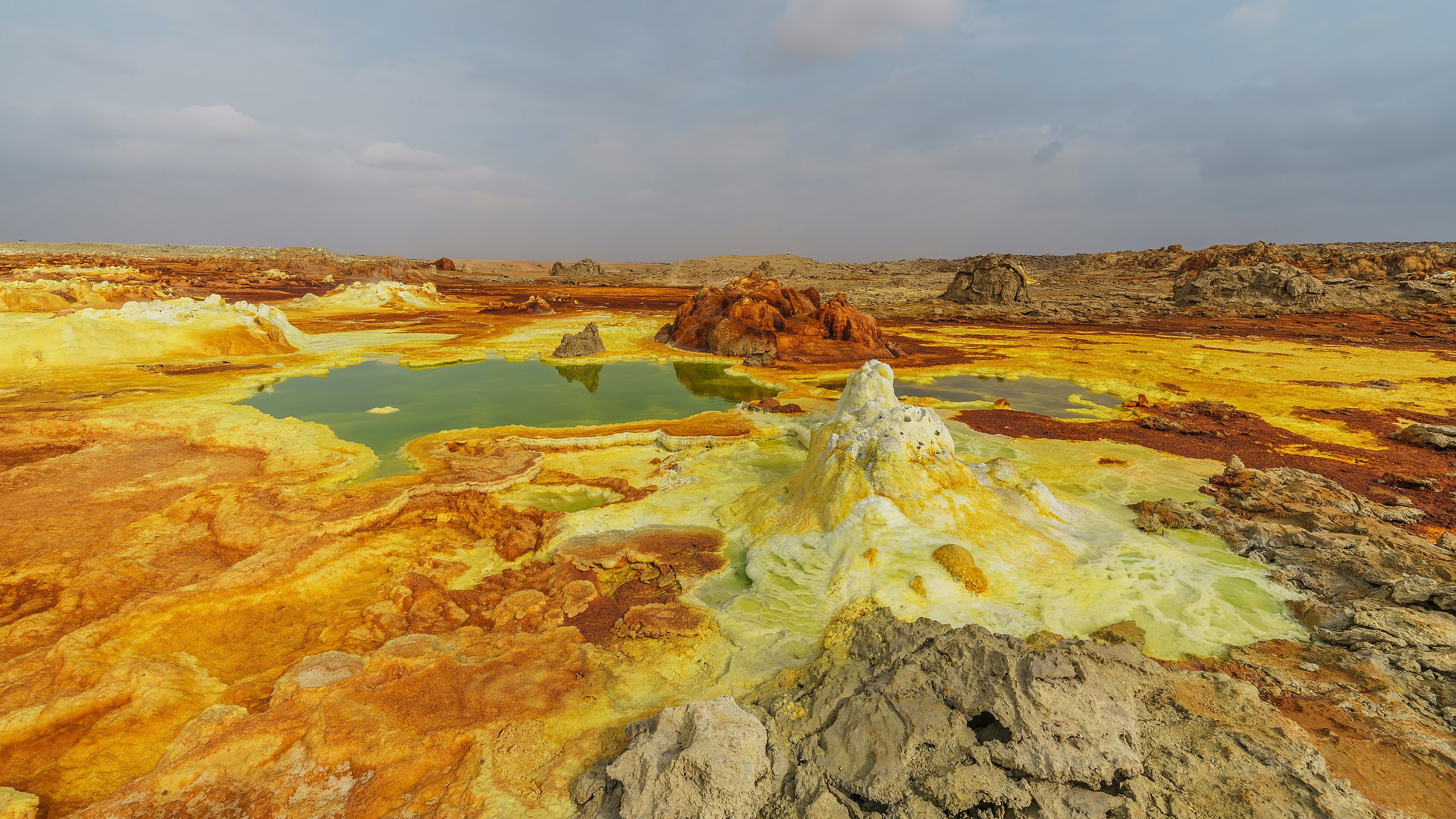
Polski: Formacje siarki i soli powstałe przy gorącym źródle na wulkanie Dallol położonym w kotlinie Danakilskiej, w regionie Afar, w Etiopii.
Русский: Пейзаж у вулкана Даллол, регион Афар, Эфиопия
Čeština: Krajina se solnými a sirnými útvary a horkými prameny v sopečné formaci Dallol v Danakilské proláklině, Ethiopie.
Español: Paisaje con aguas termales y formaciones de sal y azufre en el volcán Dallol, región Afar, Etiopía
Magyar: Kén- és sóképződmények forró forrásokkal a Dallol vulkánon (Danakil-mélyföld, Afar szövetségi állam, Etiópia)
Nederlands: Warmwaterbronnen, zout- en zwavelformaties op de Dallol, een vulkaan in de Ethiopische regio Afar
Português: Paisagem com águas termais e formações de sal e enxofre no vulcão Dallol, região Afar, Etiópia
|
| Date | |
| Source | Own work |
| Author | A.Savin |
| Permission (Reusing this file) |
Free Art License. Free usage of the photo; usually no need to ask for approval. Лицензия Свободное искусство. Использование фотографии бесплатно; согласование обычно не требуется. Lizenz Freie Kunst. Nutzung des Fotos kostenlos; Anfrage in der Regel nicht erforderlich.
Thank you. |
| Camera location | | View this and other nearby images on: OpenStreetMap |
|---|
|
This image was selected as picture of the day on Wikimedia Commons for 21 October 2019. It was captioned as follows: English: Landscape of salt and sulfur formations and hot springs on Dallol volcano, Afar Region, Ethiopia Other languages:
Čeština: Krajina se solnými a sirnými útvary a horkými prameny v sopečné formaci Dallol v Danakilské proláklině, Ethiopie. English: Landscape of salt and sulfur formations and hot springs on Dallol volcano, Afar Region, Ethiopia Español: Paisaje con aguas termales y formaciones de sal y azufre en el volcán Dallol, región Afar, Etiopía Magyar: Kén- és sóképződmények forró forrásokkal a Dallol vulkánon (Danakil-mélyföld, Afar szövetségi állam, Etiópia) Nederlands: Warmwaterbronnen, zout- en zwavelformaties op de Dallol, een vulkaan in de Ethiopische regio Afar Polski: Formacje siarki i soli powstałe przy gorącym źródle na wulkanie Dallol położonym w kotlinie Danakilskiej, w regionie Afar, w Etiopii. Português: Paisagem com águas termais e formações de sal e enxofre no vulcão Dallol, região Afar, Etiópia |
Licensing
| Copyleft: This work of art is free; you can redistribute it and/or modify it according to terms of the Free Art License. You will find a specimen of this license on the Copyleft Attitude site as well as on other sites. |
File history
Click on a date/time to view the file as it appeared at that time.
| Date/Time | Thumbnail | Dimensions | User | Comment | |
|---|---|---|---|---|---|
| current | 23:23, 26 March 2019 | | 7,952 × 4,473 (12.12 MB) | wikimediacommons>A.Savin | redeveloped, vign./levels |
File usage
The following 2 pages use this file: